Mooring Lines on Varying Water Levels
By the Richardson half of Richlow
The waterways of the region covered by Richlow require a different mind-set to the canals of the main system. Even on the Fossdyke the levels depend on the rivers Witham and Till.
We own a narrowboat but the vast majority of our boating, over many years, has been on tidal rivers. But on any river, and with heavy rain some canals, the water levels are variable and this must be borne in mind when mooring-up.
To allow a boat to rise-and-fall safely the mooring lines (ropes) should not be short and tight, but when lengthy they still need to control the boat alongside the bank . We've found that, at the stern, both requirements can be easily be achieved by using the off-side line to tie the boat to the shore. We have both stern lines rigged to use this method wherever we are - even on canals we find the boat rides snug against the bank (where there's enough depth of course!).
The usual shape of narrowboat bows makes this option less effective at that end, but by running the line to the bank ahead of the boat a safe length can be achieved.
Running lines from the off-side is the standard method used by those responsible for mooring vessels considerably larger than our narrowboat.
(Clicking on a picture will, with most operating systems, present a larger image.)
The boats of the Humber Keel & Sloop Preservation Society on their summer home moorings at South Ferriby. www.keelsandsloops.org.uk
The River Ancholme is used as a major drainage outlet and levels can change substantially - increased by major rainfall, and decreased by the water being pumped out into the Humber.
This is allowed for by keel Comrade, on the inside, and sloop Amy Howson on the outside, both being moored by lines from their off-sides.
HMS Tyne at Immingham Docks Open Day in 2012. Her aft mooring line can clearly be seen, it ran to a bollard on the dockside.
For caption completeness - in the foreground are the Humber sloops Phyllis www.sloopphyllis.com and Spider T www.spidert.co.uk
And finally - on any waters having a mooring line from anywhere high on a boat is not a good idea, but where the water levels are variable it's a dangerous thing to do.
A mooring line from the roof of the green narrowboat in this picture is restricting the boat's ability to cope with the rising levels and that's why it's heeling over.
This is at Castleford and the owner probably thought "I'm in a lock-cut with flood-gates at each end so it'll be OK." But the very high levels in the River Aire were causing water to come through the top slats of those flood-gates.
Of course we went and sorted things out.
Friday 14 December 2012
Thursday 22 November 2012
A Boat Like No Other
What's Under the Covers?
It’s mid November 2012, and what’s under the covers? It’s a narrowboat being built, and it's no exaggeration to write that it’s of a kind the like of which you have probably never seen. Not because she’s a new design - the exact opposite in fact.
But she’s not a replica, instead she’s the next in line of her unique class, it’s just that it’s been over eighty years since the last one was built. A cargo-carrying wooden narrowboat with hybrid power systems - horse and sail.
________________________________________
Boats such as these operated on a standard narrow canal, a waterway built to the same dimensions as many at the centre of the national network. But because the Chesterfield Canal is on the fringes of that network its narrowboats did not develop in the same way as elsewhere. Instead they remained unchanged over centuries and were never adapted to engine power.
They had two cabins, one in the bows and the main one at the stern, but they were below, with access through hatches in the decks.
There was a crew of two, who did not live on the boat. They always had homes ashore.
The fundamental influences on their design, other than the narrow canal dimensions, were the vessels that plied the Trent and the other rivers of the region, especially the inland keels. This was bound to happen because the same men built both types. Therefore, the narrowboats of the Chesterfield Canal could be described as narrowkeels, a development not seen anywhere else - in the world!
Unfortunately none of these craft survived the end of cargo-carrying on the Chesterfield Canal, in the 1950s. However, one, named Ida, survived long enough for astute people to measure, photograph, and note her dimensions - people who then waited many decades for the opportunity to create a new Chesterfield Canal narrowboat - and that’s what’s under the covers.
________________________________________
Her name has not yet been announced, but she is being built by the New Dawn Project, and it's being done by using traditional tools, materials and methods, no power options here. The workforce consists of members of the Chesterfield Canal Trust led by the man whose knowledge makes it all possible, David Bownes, a boat-builder who worked on repairing these boats many years ago. The funding was raised amongst the membership of the CCT, plus donated materials, such as flannelette, hand-tools, clamps and wooden ladders.
So in November 2010 they set to, the team of volunteers learning from scratch some of David's wood-working skills. It was a steep learning curve but they were fulfilling a dream.
November 2010. The boat will be built on the stocks, the trellis-like forms, which have already been made by hand. The two planks being worked on are the first of the many "bottoms" which will, you've guessed it, form the bottom of the boat. Being planed and drilled by hand - as has everything else.
The kind of tools used.
The gaps between the edges of the side planks (strakes) will be sealed.
In the second strake up can be see the type of joint used to fit them together along the sides.
A major operation has been steaming some of the strakes to bend them around to form the shape of the bows and the stern.
The upright timbers are the headstock, a temporary fixture keeping the bow timbers in place until they are locked in by other permanent planking.
It's labourious work, but fulfilling. Probably a once in a life time opportunity.
The countersunk bolt holes will be plugged with tar and resin.
Steamed strakes near the stern. Again a temporary headstock can be seen, holding the planks in place, the same as at the bows.
This scene is so evocative of the entire project.
It's of another age, and smells of tar and timber.
When the boat is finished there will be no sign of what is called "traditional" roses-and-castles canalware decoration - that didn't spread to this part of the network.
What she will have, at some time in the future, is a mast and sail for when she ventures out onto the tidal Trent. The boatmen of the Chesterfield Canal had no fear of the river, but plenty of respect, because it allowed them to reach other markets for their cargoes.
A model giving an impression of what the bows and stern of this unique narrowboat will look like.
Geography ordained that the narrowboats of the Chesterfield Canal would be of a unique type. Soon, there will be a new one.
Friday 16 November 2012
Chesterfield Canal - Stret Lock
Chesterfield Canal - A Richlow Guide
Page 24. Stret Lock, Worksop
This sometimes too narrow narrow lock is being widened by CRT (see Updates - October 2012). A task welcomed after decades of difficulties for a minority of boats that could not pass through its chamber.
There is a unique opportunity to visit these works on a CRT Open Day, Sunday, 25 November. Visitors will be able to walk inside the lock-chamber, and see and ask how this skilled operation is being undertaken.
Booking is NOT required. Site open from 9.00am, last entry strictly 3.15. Site closes 3.45. Sturdy footwear or wellies.
A57 Worksop Bypass - A60 roundabout (Sainsbury's), the lock is at the side of The Lock Keeper pub, parking available in the pub's car-park. Post code for sat-navs S80 1TJ.
An access ramp to the lock, and across to the chamber, is being installed.
(Photo 16 November).
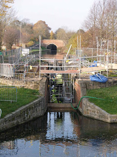
Installation is also underway of steps down into the chamber. (Photo 16 November).
The towpath has remained open during these works.
Page 24. Stret Lock, Worksop
This sometimes too narrow narrow lock is being widened by CRT (see Updates - October 2012). A task welcomed after decades of difficulties for a minority of boats that could not pass through its chamber.
There is a unique opportunity to visit these works on a CRT Open Day, Sunday, 25 November. Visitors will be able to walk inside the lock-chamber, and see and ask how this skilled operation is being undertaken.
Booking is NOT required. Site open from 9.00am, last entry strictly 3.15. Site closes 3.45. Sturdy footwear or wellies.
A57 Worksop Bypass - A60 roundabout (Sainsbury's), the lock is at the side of The Lock Keeper pub, parking available in the pub's car-park. Post code for sat-navs S80 1TJ.
An access ramp to the lock, and across to the chamber, is being installed.
(Photo 16 November).
Installation is also underway of steps down into the chamber. (Photo 16 November).
The towpath has remained open during these works.
Labels:
Chesterfield Canal
Thursday 15 November 2012
Updates - November 2012 (2nd)
South Yorkshire Waterways
Page 32 Nav Notes, and Map 12 - Rotherham Moorings
Below Rotherham Lock there has always been a length of moorings but until recently it has been out of use, with no pedestrian access to/from them. The moorings have now been re-opened as part of the rebuilding of Rotherham Central railway station, with a ramp up to the station's adjacent car-park.
The moorings are about double the length shown here.
At the top of the ramp is the station car-park. The red buildings are on the main road. Turn left, and over the railway, for a Lidl supermarket.
Turn right for the bus station and the town centre.
There is also a taxi-rank by the side of the railway station.
South Yorkshire Waterways - a guide to the whole of the Sheffield & South Yorkshire Navigation (SSYN). Available from www.richlow.co.uk Written by People Who Go There!
Twitter @richlowguides
Friday 2 November 2012
Updates - November 2012
South Yorkshire Waterways
Page 18. Thorpe Marsh Power-Station Demolished
This power-station was at the junction of three waterways, the New Junction Canal, the Don Navigation, and the Stainforth & Keadby Canal. It's cooling-towers were a navigational aid visible for many miles across the flat landscape. It ceased operation in 1994 and I took the following pictures in that year, thinking I would soon have "before" and "after" scenes.
Eighteen years later! - Thorpe Marsh power-station has eventually gone, to be replaced with a gas-fired type on the same site.
Stainforth & Keadby Canal - approaching Bramwith Lock.
Stainforth & Keadby Canal - above Bramwith Lock the power-station seemed further away.
On the New Junction Canal.
The demolition of Thorpe Marsh power-station has made a major change to the landscape for three of the waterways of the Sheffield & South Yorkshire Navigation.
Our guide to the SSYN is available from www.richlow.co.uk
Twitter @RichlowGuides
Monday 29 October 2012
Updates - October 2012
Chesterfield Canal - A Richlow Guide
Page 24. Shireoaks Marina Pump-out
The self-operated pump-out facility has been out of action for some time. Please check with the regional CRT (p41) if this may be a problem on your cruise.
Page 24. Stret Lock
The narrowness of the chamber of this lock has caused problems for decades, some narrowboats finding they could not pass through. This applied to some converted working-boats, but also to modern craft built with slightly extended base-plates. But the good news is that CRT has today started a major project to solve the problem, scheduled to be completed by 10 December.
Page 36. New slipway at Staveley Town Basin
Slipways section. The recently opened Staveley Town Basin (map 11) has a slipway. Usage can be arranged by contacting Tapton Lock Visitor Centre, Chesterfield. Contact details p41.
Monday 16 July 2012
Updates - July 2012 (2)
Narrowboat on the Trent
Maps on Page 30, and Back Cover - High Marnham Power Station
Boaters on the tidal Trent gain confidence with the sight of prominent landmarks confirming their position. One such landmark was removed at the weekend with the demolition of the towers at High Marnham Power Station.
Therefore, references to the Power Station should be removed from the maps on the pages shown above.
The charts produced by The Boating Association should also be amended. On the old-style it is Chart 2. On the new-style photographic it is on Page 4.
And to prove it...http://www.bbc.co.uk/news/uk-england-nottinghamshire-18847674
Friday 13 July 2012
Updates - July 2012
South Pennine Ring - Part 1
New Manchester moorings on the Rochdale Canal
Map 8. Islington Marina at Ancoats is now open for business. A side arm has been constructed off the Rochdale Canal opposite Redhill Street between locks 81 and 82.
The new Marina presently offers visitor moorings free of charge for up to two weeks and is ideally located for exploring the City Centre. It is equipped with a deluxe sanitary station complete with showers, washing machines and pump out equipment. Long term moorings can be arranged by phoning 0161 839 2999.Looking back to the Rochdale Canal which runs left to right in front of the former warehouses. The new sanitary station is on the left and visitor moorings on the right.
Eventually new development will surround the waterspace.
Looking across to the long-term moorings, the waterspace is very attractively laid out.
Since reopening of the Rochdale Canal, passage of the long flight of nineteen locks above Piccadilly has been supervised and boaters have to book to pass through locks 65 – 83 which have been kept locked as an anti-vandalism measure. As the new marina lies above lock 82, Brownsfield Lock 83 and Ancoats Lane Lock 82 are no longer locked so the marina can be reached at any time from Ducie Street Junction.
"Manchester" and "Rochdale" Locks
Map 8. For boaters booking the passage British Waterways formerly named locks 65-83 the “Manchester 19 Locks” - amusingly they have re-branded locks 65-81 the “Rochdale 18 Locks”, even though there are only seventeen of them!
Friday 15 June 2012
Images of - South Pennine Ring - Part 2
In 2010 whilst researching the second part of Richlow's two South Pennine Ring guides, John & Barbara cruised their boat nb Madeley Wood from Sowerby Bridge to Ashton - along the Huddersfield Broad and Narrow canals.
They also walked the entire route, including over Standedge Tunnel (twice!).
These photographs reflect their experiences, and may perhaps encourage others to boat across the Pennines.
At Salterhebble, on the Calder & Hebble Navigation. Note the unique handspike-operated gate paddles (or "cloughs" as they are know locally).
The start of the Huddersfield Broad Canal at Cooper Bridge. nb Thief of Time is leaving the River Calder and entering lock no.1.
.jpg)
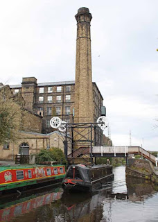
The unique Locomotive Bridge on the Huddersfield Broad Canal, in Huddersfield. The deck remains horizontal and is lifted on wire ropes.
When we first started boating here, we used to wind a handle and hope the road traffic would stop. Now there are road-barriers and the bridge lifts electrically at the push of a button.
For some reason British Waterways have recently put up bridge-name signs calling this Quay Street Bridge - but we think it will always be known as Locomotive Bridge.
.jpg)
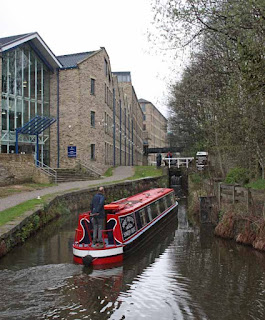
One of Shire Cruisers hire boats entering Lock 1E, the first lock on the Huddersfield Narrow Canal. The locks on the Huddersfield side of the Pennines are numbered with an "E" suffix, those on the Ashton side with a "W".
As part of the Millennium restoration of the Huddersfield Narrow Canal, a new tunnel was constructed beneath the Sellers factory, and a new Lock 3E was installed at the upstream end. Now in 2012 the factory has been relocated and the site is being redeveloped. As a result, the tunnel has been abandoned, with the canal rebuilt at ground level. A third Lock 3E has been built close to the original one, which boats sail straight through near Chapel Hill. The towpath is now open through this section.

On a walking visit over the tunnel top we accompanied a group from the Horse Boating Society, with their horse Bonnie. The rough nature of the high Pennine hills can be seen, and also some of the tunnel ventilation shafts.
Moored outside Brownsfield Visitor Centre, where the impressive Saddleworth viaduct spanning across Lock 23W.
As a result of the restoration of the Huddersfield Narrow Canal, Greenfield has become a popular tourist venue. There are pleasant, convenient moorings from which to visit the museum, small shops, cafes and pubs, in this thriving little town.
The "other" tunnel on the Huddersfield Narrow - the short Scout Tunnel between locks 12W and 11W - cut through a rocky bluff in the valley side. It is unlined and has a towpath, giving walkes an opportunity to see the naked Pennine rock.
Stalybridge. Where else can you moor up in a town centre like this! Good moorings to explore this Lancashire mill-town.
There are some excellent small shops including this gem.
Where else but in Lancashire?
We hope these images may encourage more visitors to the Huddersfield canals - Broad and Narrow.
They also walked the entire route, including over Standedge Tunnel (twice!).
These photographs reflect their experiences, and may perhaps encourage others to boat across the Pennines.
At Salterhebble, on the Calder & Hebble Navigation. Note the unique handspike-operated gate paddles (or "cloughs" as they are know locally).
The start of the Huddersfield Broad Canal at Cooper Bridge. nb Thief of Time is leaving the River Calder and entering lock no.1.
.jpg)
The unique Locomotive Bridge on the Huddersfield Broad Canal, in Huddersfield. The deck remains horizontal and is lifted on wire ropes.
When we first started boating here, we used to wind a handle and hope the road traffic would stop. Now there are road-barriers and the bridge lifts electrically at the push of a button.
For some reason British Waterways have recently put up bridge-name signs calling this Quay Street Bridge - but we think it will always be known as Locomotive Bridge.
.jpg)
One of Shire Cruisers hire boats entering Lock 1E, the first lock on the Huddersfield Narrow Canal. The locks on the Huddersfield side of the Pennines are numbered with an "E" suffix, those on the Ashton side with a "W".
Lock 3E and Sellers Tunnel
Now you see them -
now you don't!
As part of the Millennium restoration of the Huddersfield Narrow Canal, a new tunnel was constructed beneath the Sellers factory, and a new Lock 3E was installed at the upstream end. Now in 2012 the factory has been relocated and the site is being redeveloped. As a result, the tunnel has been abandoned, with the canal rebuilt at ground level. A third Lock 3E has been built close to the original one, which boats sail straight through near Chapel Hill. The towpath is now open through this section.
Leaving Huddersfield behind, the scenery becomes more rural on the approach to Lock 12E.
The landscape is spectacular in the upper Colne valley between Slaithwaite and Marsden. Boating is hard work with the locks close together, has seen here at Lock 27E.
The Colne valley bottom was lined with stone-built water-powered mills and their dams. Many still remain - this one is at Sparth below Lock 32E.
Marsden Locks blend beautifully into the landscape.
Standedge Tunnel is the highlight of navigating the Huddersfield Narrow Canal. Tunnel passages have to be booked in advance. We had to wear safety equipment to boat through the three and a quarter mile tunnel, and we were accompanied by a pilot. The tunnel is full of interest but our cat was terrified by the echoes, especially those of trains passing in the adjacent railway tunnel.

On a walking visit over the tunnel top we accompanied a group from the Horse Boating Society, with their horse Bonnie. The rough nature of the high Pennine hills can be seen, and also some of the tunnel ventilation shafts.
Moored outside Brownsfield Visitor Centre, where the impressive Saddleworth viaduct spanning across Lock 23W.
As a result of the restoration of the Huddersfield Narrow Canal, Greenfield has become a popular tourist venue. There are pleasant, convenient moorings from which to visit the museum, small shops, cafes and pubs, in this thriving little town.
The "other" tunnel on the Huddersfield Narrow - the short Scout Tunnel between locks 12W and 11W - cut through a rocky bluff in the valley side. It is unlined and has a towpath, giving walkes an opportunity to see the naked Pennine rock.
Stalybridge. Where else can you moor up in a town centre like this! Good moorings to explore this Lancashire mill-town.
There are some excellent small shops including this gem.
Where else but in Lancashire?
We hope these images may encourage more visitors to the Huddersfield canals - Broad and Narrow.
If so, the Richlow guide South Pennine Ring - Part 2 is available post free from www.richlow.co.uk
Tuesday 5 June 2012
Updates - June 2012
South Pennine Ring - Part 2
Map 16, page 28, Huddersfield Narrow Canal
Seller's Tunnel (23), Huddersfield (See Navigation Notes, Towpath Notes and Text).
On our visit on June 1st, workmen were still completing works to the navigation and towpath. A new lock 3E has been constructed just upstream of Chapel Hill Bridge - this is the third in the history of the canal! Seller’s Tunnel has effectively been abolished and the canal raised to ground level upstream of the new lock. The towpath is now continuous between Chapel Hill Bridge and Longroyd Bridge (25), so walkers now only need to divert between Chapel Hill Bridge and Queen Street Bridge (22).
Important note for boaters - there is still no pedestrian access along the towpath to Lock 2E, so boat crews must be picked up and travel on the boat between locks 3E and 1E.
Looking upstream from Chapel Hill Bridge. Just behind the photographer are steps leading up from a landing for boat crews. Beyond the new Lock 3E is a 200ft passing place and the new narrow canal channel which replaces Seller’s Tunnel. Construction work continues on the new development on the right.
Friday 1 June 2012
Images of - South Yorkshire Waterways
South Yorkshire Waterways guide - available from http://www.richlow.co.uk/
The Sheffield & South Yorkshire Navigation (SSYN) which includes the Don Navigation, and the New Junction, Stainforth & Keadby and Sheffield & Tinsley canals.
These waterways probably have the widest variety of navigational features, and the same can be said of the surroundings - including flat rural fenland and a climb to a city centre.
As a result the following pictures only give a taste of the SSYN, but hopefully they will encourage boaters to visit these surprisingly remote waterways.
They were taken in 2011 during Richlow's research for our South Yorkshire Waterways guide. Richlow guides - Written by People Who Go There!
These are wide waterways, no need to look for winding holes.
On the right is Humber super-sloop Spider T on her Keadby home mooring. She took part in the Diamond Jubilee Pageant on the Thames in 2012.
Commercial traffic uses the New Junction Canal and the Don Navigation (here at Mexborough) so they are even wider.
There are many types of bridges - this one on the Stainforth & Keadby Canal is operated by the railway signalman.
Whereas, this one on the New Junction Canal is power-operated by boaters.

Some locks are manually operated - others look as if they are but this one at Thorne is also power-operated.
Other locks are somewhat larger, and are obviously beyond balance-beam pushing!
And this is how the large modern locks and moveable bridges are operated. Insert a BW (C&RT) key and press the buttons. It's a controlled operation, with lock paddles gradually opening to prevent turbulence.
Lock-side posts have white bands which rise and fall to indicate the position of the paddles. Here one shows the paddles have started to rise - at this stage they will be opening very slowly.

The SSYN has canals - as here at Thorne which is the major boating supplies centre.
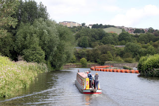
It also includes the River Don - here between Rotherham and Sheffield, with a weir clearly marked.
And it has a canal over a river - the New Junction Canal crossing the tidal River Don.
Yes, there is commercial traffic - that's why boaters have the luxury of power-operated bridges and locks.
This is Humber Pride, but the Goole-Rotherham run is usually done by her sister Humber Princess. Once or twice a week.
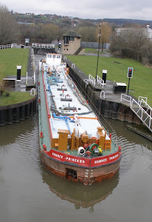
Humber Princess at Aldwarke, showing why the locks are the size they are.
The Richlow guide has tips and information about sharing the SSYN with girls like this.
Humber Princess has a retracting wheel-house for this bridge at Aldwarke.
Beyond the head of commercial navigation, the stretch between Rotherham and Sheffield is more pleasant than may be imagined.
Tinsley Locks, on the climb up to the summit level of the Sheffield & Tinsley Canal
On the Sheffield & Tinsley Canal - overhead one of Sheffield's modern trams, which provide a good way to explore the city and its suburbs.
The Richlow guide includes information on Sheffield's events and entertainments, and public transport to visit the surrounding Peak District.
The final mile to Victoria Quays is typical of the approach to a city centre - but most of the industry has moved away from the canal.
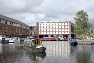
Richlow's flag-ship Madeley Wood in Sheffield basin (Victoria Quays). A pleasant and surprisingly quiet location.
We hope these pictures may tempt you to visit this part of the national waterways network.
Subscribe to:
Posts (Atom)
.jpg)


.jpg)
.jpg)


.jpg)
.jpg)
.jpg)
.jpg)
.jpg)
.jpg)
.jpg)

.jpg)
.jpg)
.jpg)
.jpg)


